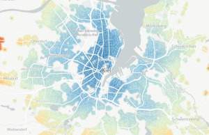
For the last half year or so, I worked on my master thesis project which explores using a walkability index to plan for auto-reduction measures in Kiel. Learn more and find a link to the full thesis in this post.
Tagged “gis”
These are the results of a study I outlined in a previous blog post. In it I show the and compare the speeds of bicycling, driving and public transit.
With this article, I want to propose a method for investigating how fast it takes to travel using different modes in the city of Kiel in Germany.
Look at how I used several differnt data sources to create a map of Portland's crime data with a link to the live example.


